01273339263

Highway Design
During my undergraduate studies at AUC to complete my BS in Construction Engineering, and as part of my Infrastructure Engineering Concertation I took a Highway Design course. In this course we were tasked to design a highway by utilizing the AASHTO and Egyptian code to yield the most economical and safest alternative to reach the final destination.
This project was done under the instruction and supervision of Dr. Maram Saudy

The Components of the Project
In order to complete the project, two programs were used: Autodesk Civil 3D and Microsoft Office Excel. Civil 3D was heavily used in the analysis and design of the highway while Excel was used in the numerical and cost analysis of the highway.
 Established Three Alternatives.PNG |  Sample of Developed Verical Curves.PNG | 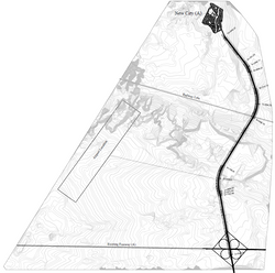 Chosen Alternative |
|---|
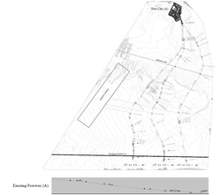
Finding the Different Alternatives and Choosing the Optimum Route
In order to find optimal route and design, three alternatives were made. Each alternative had its own cut and fill volumes as each route passed over its own representative unique topography. The alternative routes were made to favor the way the contour lines are shaped in order to decrease the volumes of soil handled, thus lowering the cost of the project.
The vertical curves produced showed a rough estimate the volumes of cut and fill and the total length of the highway. This allowed the team to choose the most economical alternative and thus further develop it.
 Sample Detailed Plan Profile |  Pavement design Cross Section |  Typical Road Cross Section |
|---|---|---|
 Sample Points Table |  Sample Cut and Fill Tables |
Designing the Highway
After Choosing the most suitable alternative, the team was ready to start the design. The demand, lane widths, average flow, design level, design speeds, types of vehicles and all related factors were taken into consideration in order to produce the highway's required level of service, the minimum design radius and the suitable K values. Excel and the AASHTO were utilized to produce the design values according to the learned methodology.
The produced design documents of the highway included the designed pavement cross section, points table, detailed cut and fill tables at equal increments, and a very detailed plan profiles drawings that show both the design of the horizontal and vertical curve designs and alignments. All the produced designs were made using Autodesk Civil 3D and the design drawings were made using Autodesk AutoCAD.
 four Cloverleaf Interchange |  Sample Section #2 | 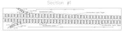 Sample Section #1 |
|---|
Four Cloverleaf Interchange
In order to allow access from the existing highway to the newly design highway, an interchange needed to be designed. The interchange needs to allow smooth access to the vehicles to all outlets without causing any interruptions to the flow. Therefore the Interchange to be designed will be the Four Cloverleaf as it will allow easy maneuvering and will not stop the flow of the highway.
The lane widths and minimum radii was obtained from the AASHTO and this allowed the team to design he intersection utilizing Autodesk AutoCAD.